

For over 500 years, a mysterious island appeared on maps of the Atlantic — sitting roughly 321 kilometres off the Galway coast, shrouded in mist and legend. Cartographers across Europe marked it. Sailors went looking for it. Some claimed to have seen it. Nobody ever managed to land on it twice.
The island was called Hy-Brasil.
What Was Hy-Brasil?
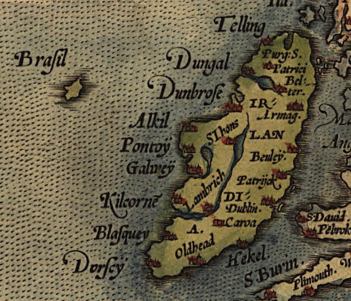
Hy-Brasil — also written as Hy-Breasal or Hi-Brasil — first appeared on a Genoese map in 1325, drawn by the cartographer Angelino Dulcert. He showed it as a near-perfect circle, divided down the middle by a straight channel, sitting in the Atlantic to the west of Ireland. Future cartographers copied it, adjusted it slightly, and kept it on their charts for the next five centuries.
The name is thought to derive from the Old Irish Í Breasal, which translates roughly as “Island of the Blessed” or relates to a mythical High King named Breasal. Some scholars connect it to the broader Celtic idea of a paradise in the western sea — a blessed land beyond the horizon where the dead could rest. Others believe it was a persistent geographic error that was copied from map to map until it gained a life of its own.
What sets Hy-Brasil apart from purely mythological places is that it appeared on serious, practical navigational charts — not just in folk tales. These were tools used by sailors and merchants. When professional cartographers placed it alongside well-documented islands like the Azores and Iceland, they were treating it as a real geographic feature worth marking.
Subscribe to our free newsletter for more hidden stories from Ireland — join here.
The Maps That Kept It Alive
☘️ Your Irish family has a story waiting to be found.
Discover where your Irish ancestors came from — their county, their name, their story. Our free step-by-step guide walks you through every record, DNA tool, and ancestry archive. No experience needed.
From the 14th century onward, Hy-Brasil appeared on dozens of European maps. It was plotted by Portuguese, Spanish, Italian and Dutch cartographers. The location shifted slightly from map to map — sometimes shown as circular, sometimes pear-shaped, sometimes divided by a central strait — but it always appeared west of Ireland, in roughly the same stretch of the North Atlantic.
On the 1375 Catalan Atlas, one of the most celebrated medieval maps ever produced, it appears labelled as “Illa de Brazil.” The 1436 Bianco Atlas marks it clearly. Abraham Ortelius, the Flemish cartographer who produced one of the first modern world atlases in 1570, included it. Gerardus Mercator — whose projection method still shapes how we picture the world — marked it too.
For a place that no one could reliably find, Hy-Brasil had remarkable staying power. It finally began disappearing from serious navigational charts around the 1860s — roughly five and a half centuries after it first appeared.
The Sailors Who Claimed to Have Found It
The island was not simply a cartographic curiosity. Several documented accounts describe sightings and claimed landings.
In 1480, Bristol merchants funded an expedition specifically to find Hy-Brasil. The voyage returned empty-handed. A second Bristol expedition followed in 1481 — again, no island. Then in 1497, John Cabot set sail on his famous voyage towards North America, departing Bristol with the belief that Hy-Brasil lay somewhere along his western route.
The most detailed claimed sighting comes from a 1674 account describing a Scottish sea captain named John Nisbet, whose crew were said to have gone ashore and spent a day on the island, meeting an elderly man who gave them gold and silver. The credible Irish scholar Roderick O’Flaherty also recorded accounts of Hy-Brasil sightings from the western coast in his 1684 writings. The Nisbet story in particular has been questioned by later scholars, some of whom believe it originated as literary fiction that gained credibility by circulating alongside more serious academic work. Neither Nisbet nor anyone else ever found the island a second time.
A separate account from the same period described a Captain Alexander Johnson also landing briefly before the island disappeared into mist. These stories circulated widely and were taken seriously enough to be recorded and published by credible scholars of the period.
Want more surprising Irish history delivered to your inbox? Sign up free here.
Why Did It Disappear from the Maps?
The decline of Hy-Brasil from European cartography in the 19th century coincided with the era of systematic oceanic surveying. The British Admiralty and other naval powers were producing increasingly accurate charts based on direct measurement rather than accumulated tradition. If an island could not be found, it was not marked.
By the time survey vessels were working the North Atlantic in detail, there was no island 321 kilometres west of Galway to find. The ocean floor in that region sits at depths of 2,000 to 3,000 metres — far too deep for any island that could have existed in historical times to have simply sunk below the surface.
The most widely accepted explanation today is that Hy-Brasil was a persistent cartographic error, reproduced from one map to the next with enough authority to survive for centuries. Once a feature appeared on a respected chart, other cartographers often copied it without independent verification — a problem that created numerous “phantom islands” on historical maps across the world.
A related theory points to the Porcupine Bank, a shallow underwater plateau roughly 200 kilometres off the Irish west coast. At its shallowest point, it sits around 150 metres below the surface. Some researchers have suggested it may have behaved differently during periods of lower sea levels after the last ice age, though whether any feature here was ever visible above water remains speculative.
The Science Behind the Phantom
Some researchers point to a phenomenon called Fata Morgana — a type of superior mirage that occurs over cold water when warmer air sits above the sea surface. This atmospheric effect can make distant objects appear to float above the horizon or create convincing illusions of land where none exists.
The North Atlantic, with its sharp temperature contrasts between cold deep water and warm surface air, is well suited to producing these effects. A ship’s crew seeing what appeared to be an island on the horizon, then unable to reach it or find it again, would have had no framework for understanding what they saw. Recording it as an island would have seemed entirely reasonable.
Other researchers have suggested that some phantom island sightings may reflect genuine but transient features — large icebergs mistaken for land, or ice floes drifting south from the Arctic. The North Atlantic in the medieval period likely had different patterns of sea ice than today, and large formations could conceivably have been misidentified by mariners at a distance.
Hy-Brasil in Irish Legend
In Irish mythology, the idea of a blessed island to the west long predates the first map that ever marked Hy-Brasil. The concept appears in early Irish texts as Tír na nÓg — “the Land of Eternal Youth” — and the similar Mag Mell, “the Pleasant Plain.” These were places beyond the sea where time moved differently and sorrow did not exist.
The hero Bran mac Febal was said to have sailed there. The warrior-poet Oisín was taken there by the fairy woman Niamh. The theme of a paradise island visible only at certain times, accessible only to the chosen or the fortunate, runs through Irish mythology with remarkable consistency across the centuries.
Whether the cartographic Hy-Brasil was named after these mythological traditions, or whether the mythology helped give the map feature its staying power, is difficult to untangle now. The two versions — geographic and legendary — appear to have reinforced each other over time. Some legends even specify that the island rises above the waves once every seven years, only to sink again before anyone can reach it permanently.
Join thousands of readers who love Ireland’s hidden history — subscribe to our free newsletter.
Visiting the West Clare and Galway Coast Today
You cannot visit Hy-Brasil — it is not there. But the coastline from which sailors once set off in search of it is very much real and worth the journey.
The Cliffs of Moher in County Clare rise 214 metres above the Atlantic at their highest point and stretch for approximately 14 kilometres along the coast. On a clear day, the Aran Islands are visible from the cliff top — and it is from this stretch of Ireland’s western edge that the phantom island was reportedly most often sighted. Standing at the cliff edge and looking west, it is not difficult to understand why sailors believed something lay further out.
The Aran Islands — Inis Mór, Inis Meáin and Inis Oírr — sit in Galway Bay and reward a day trip. Inis Mór is the largest and home to Dún Aonghasa, a semi-circular stone fort perched on a 100-metre cliff above the Atlantic. It dates to around 1100 BCE, predating the first Hy-Brasil maps by well over two thousand years.
The Wild Atlantic Way runs along the entire western coastline, connecting the Cliffs of Moher and the Aran Islands to Connemara to the north and the Burren to the south. The Burren is a limestone plateau covering roughly 250 square kilometres of County Clare — one of the most geologically unusual landscapes in Europe, with Arctic, Mediterranean and Alpine plants growing side by side in the cracks of the rock.
Ferries to the Aran Islands run from Rossaveal in County Galway and from Doolin in County Clare. Rossaveal is about 45 minutes from Galway city; the crossing to Inis Mór takes roughly 40 minutes. Doolin is a 10-minute drive from the Cliffs of Moher and offers a crossing to Inis Mór of around 35 minutes on the express ferry, or up to about 75 minutes on standard sailings. Both routes operate year-round, though winter crossings depend on sea conditions.
No map shows Hy-Brasil today. It has been written off as a mistake, a mirage, a legend that outlasted its usefulness. But for five hundred years, it was taken seriously enough to mark by serious people — cartographers, merchants, explorers. Whatever it was — persistent error, optical illusion, or something the Atlantic has since reclaimed — it left a clear mark on how Europe imagined the ocean to the west of Ireland.
The waters off Galway are still there. They still produce fog and strange light and unusual effects on the horizon. On the right day, standing at the Cliffs of Moher, the question of what might lie beyond is not entirely unreasonable.
Thinking about it for retirement?
If you’ve started thinking seriously about retiring there, our complete our full Retire in Ireland guide covers the visa, healthcare, cost-of-living, and the regions worth shortlisting.
Tours & experiences you might love


Powered by Viator. Some links are affiliate links — we may earn a small commission at no extra cost to you.
Secure Your Dream Irish Experience Before It’s Gone!
Planning a trip to Ireland? Don’t let sold-out tours or packed attractions spoil your journey. Iconic experiences like visiting the Cliffs of Moher, exploring the Rock of Cashel, or enjoying a guided walk through Ireland’s ancient past often sell out quickly—especially during peak travel seasons.

Booking in advance guarantees your place and ensures you can fully immerse yourself in the rich culture and breathtaking scenery without stress or disappointment. You’ll also free up time to explore Ireland’s hidden gems and savour those authentic moments that make your trip truly special.
Make the most of your journey—start planning today and secure those must-do experiences before they’re gone!
Subscribe Free