

Binevenagh Mountain rises sharply from the flat plains of County Londonderry, its basalt cliffs dropping sheer to the land below. At 385 metres above sea level, it is not the highest point in Northern Ireland, but it may well be the most dramatic. Standing at the edge of the plateau, looking north across the Antrim coast and out to the Atlantic, you feel the full scale of this landscape — exposed, ancient, and indifferent to the small figure standing at its rim.
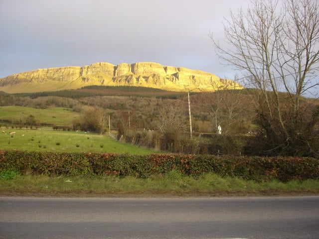
This is not a mountain that announces itself gently. The cliffs are abrupt. The wind is persistent. The views stretch further than feels reasonable. For anyone travelling the Causeway Coastal Route or exploring the north of Ireland, Binevenagh is worth a detour — not because it is famous, but because it is genuinely extraordinary.
Want more hidden gems from across Ireland? Subscribe to our free newsletter and we’ll bring them straight to your inbox every week.
Where Is Binevenagh Mountain?
Binevenagh sits in the north of County Londonderry (also known as County Derry), roughly ten kilometres south-west of the seaside town of Castlerock and about ten kilometres north-west of Limavady. It forms part of the Binevenagh Area of Outstanding Natural Beauty, a designation that covers much of the upland landscape between the coast and the Sperrins.
The mountain is the remains of an ancient lava plateau, shaped over millions of years by volcanic activity and then carved by glaciers during the last ice age. What is left is a high, flat-topped escarpment with near-vertical cliffs on the northern and eastern sides — a geological feature that makes the views from the top so sudden and so striking.
The Irish name is Binn Fhoibhne, meaning the peak of Foibhne — a figure from early Irish mythology associated with this landscape. The name has been carried across centuries of use, a small reminder that people have been drawn to this place for a very long time.
The Views from the Top
The panorama from the Binevenagh plateau is one of the best in Northern Ireland, and it rewards a clear day. To the north, the coastline stretches from Castlerock to Portstewart, with the wide sweep of Benone Strand — one of Ireland’s finest beaches — visible below. Beyond the coast, on a good day, the Paps of Jura in Scotland are visible on the horizon, roughly 105 kilometres away across the North Channel.
To the east, the Antrim plateau rolls away toward the hills above Ballycastle. To the south, the Sperrin Mountains dominate the skyline. The Foyle Valley stretches to the west, with Derry/Londonderry visible in clear conditions. The elevation means that cloud cover frequently sits below the plateau, cutting it off from the lowlands and creating an atmosphere that is genuinely otherworldly.
This is also why the mountain can feel isolating, even on a summer afternoon. When the mist rolls in from the Atlantic and drops below the cliffs, the plateau becomes an island above the clouds. It is striking and slightly unsettling in equal measure — which is exactly what makes it memorable.
Wildlife on the Cliffs
The basalt cliffs of Binevenagh are important habitat for peregrine falcons, which nest on the ledges and hunt the open ground above. If you spend time near the cliff edge, particularly in spring and early summer, you are likely to see them. Peregrines are fast — the fastest birds on the planet in a dive — and watching one hunt across the open moorland below the plateau is worth the walk alone.
The moorland on top of the mountain supports a range of upland birds, including red grouse, meadow pipits, and skylarks in season. The habitat is heather moorland and blanket bog, typical of Northern Ireland’s upland areas, and it supports a range of insects, mosses, and specialist plant species adapted to the exposure and the poor soils.
The Binevenagh Local Nature Reserve covers much of the mountain and the surrounding land, protecting these habitats and providing public access. The reserve is managed by the Northern Ireland Environment Agency (NIEA), and it is free to visit.
We cover wild places, coastal walks, and heritage sites across Ireland every week. Join our free newsletter to keep up with the best of it.
Walking and Access
The most straightforward route to the top of Binevenagh starts from a small car park on Binevenagh Road, which runs along the lower slopes of the mountain. From there, a marked trail climbs to the plateau in around 45 minutes at a steady pace. The ascent is moderate rather than difficult — there is no scrambling involved — but the path can be wet underfoot, particularly after rain, so waterproof footwear is advisable.
At the top, the path follows the cliff edge north, with the most dramatic viewpoints accessible within a short walk of the summit. The plateau itself is open moorland, and on clear days it is easy to navigate. In mist, take care near the cliff edges and use a map or GPS — the landscape is featureless and the drops are real.
The round trip from the car park takes two to three hours at a relaxed pace, including time at the viewpoints. There are no facilities on the mountain — bring water, wear layers, and be prepared for wind at the top regardless of conditions below. The weather here can change quickly, and the exposed position of the plateau means temperatures are consistently cooler than the towns below.
Getting There
Binevenagh is best reached by car. From Limavady, take the B68 road north toward Downhill, turning onto Binevenagh Road as signposted. The car park sits on the western flank of the mountain. From Coleraine or Castlerock, approach via the A2 coastal road, then turn south onto Binevenagh Road.
The nearest town with accommodation, restaurants, and shops is Limavady, about a 15-minute drive south. Coleraine, which has a wider range of facilities and a train station on the Belfast to Derry/Londonderry line, is around 20 minutes to the east.
There is no bus service to the mountain itself. Visitors without a car can take the train to Castlerock station (on the coastal line) and walk or cycle the seven kilometres to the trailhead, but the road is not ideal for pedestrians. Driving is the practical option for most visitors.
Nearby Attractions
Binevenagh sits within striking distance of several other significant sites in the north of Ireland. Benone Strand, directly below the northern cliffs, is a seven-mile Blue Flag beach that is among the finest in Northern Ireland. Access is from the A2 coast road at Benone, and it is worth combining the two in a single day trip.
Downhill Demesne, managed by the National Trust, is four kilometres to the north. The estate contains the ruins of an 18th-century mansion built by the eccentric Bishop of Derry, Frederick Hervey, along with the cliff-top Mussenden Temple — a small circular library perched on the edge of a 120-foot (37-metre) drop above the sea. It is one of the most unusual buildings in Ireland and well worth the short walk from the car park.
Further east along the coast, the Causeway Coastal Route connects Binevenagh’s area to the Giant’s Causeway (around 30 kilometres), Carrick-a-Rede rope bridge, the Glens of Antrim, and ultimately Belfast. If you are making the drive along the coast, Binevenagh makes an excellent start or end point for that journey.
When to Visit
The mountain is accessible year-round, but summer (June to August) offers the best chance of clear views and dry conditions underfoot. Spring brings nesting birds to the cliffs, making late April and May particularly good for wildlife. Autumn can produce clear, sharp days with excellent visibility, and the moorland heather is in bloom from August into September.
Winter visits are possible but require more preparation. The plateau is exposed and wind speeds at the top can be significant. Snow and ice are not uncommon from December to February, and some paths become treacherous. If you visit in winter, check the forecast carefully and turn back if conditions deteriorate.
The car park is open at all times. There is no entry fee, no booking requirement, and no visitor centre. Binevenagh remains one of those places in Ireland where you simply turn up, walk in, and find the landscape waiting for you.
A Place Worth Knowing
Binevenagh does not appear in many tourism headlines. It sits outside the main visitor trail — to the west of the Causeway coast’s most famous sites, away from the routes that carry the bulk of Northern Ireland’s tourist traffic. That is part of what makes it worth seeking out.
The mountain offers the kind of experience that is harder to find as visitor numbers to the north of Ireland have grown: a dramatic landscape, genuine solitude on most days, and views that do not require a queue or a timed entry slot. It is the kind of place that rewards the effort of finding it.
Whether you stand at the cliff edge in full sun with Scotland visible on the horizon, or in mist with the world reduced to the few metres of heather around you, Binevenagh leaves a clear impression. Northern Ireland has no shortage of remarkable landscapes — but this one, quiet and largely unannounced, holds its own against any of them.
Get more guides to Ireland’s best places — well-known and off the beaten track. Subscribe to our newsletter — it’s free and lands in your inbox weekly.
☘️ Join 64,000+ Ireland Lovers
Every weekday morning, get Ireland’s hidden gems, local secrets, and travel inspiration — the kind you won’t find in any guidebook.
Subscribe free — enter your email:
Get the free guide
Enter your email and we will send you straight to the download.
📲 Know someone who’d love this? Share on WhatsApp →
Love more? Join 43,000 Scotland lovers → · Join 29,000 Italy lovers → · Join 7,000 France lovers →
Free forever · Unsubscribe anytime
Tours & experiences you might love


Powered by Viator. Some links are affiliate links — we may earn a small commission at no extra cost to you.
Secure Your Dream Irish Experience Before It’s Gone!
Planning a trip to Ireland? Don’t let sold-out tours or packed attractions spoil your journey. Iconic experiences like visiting the Cliffs of Moher, exploring the Rock of Cashel, or enjoying a guided walk through Ireland’s ancient past often sell out quickly—especially during peak travel seasons.

Booking in advance guarantees your place and ensures you can fully immerse yourself in the rich culture and breathtaking scenery without stress or disappointment. You’ll also free up time to explore Ireland’s hidden gems and savour those authentic moments that make your trip truly special.
Make the most of your journey—start planning today and secure those must-do experiences before they’re gone!