

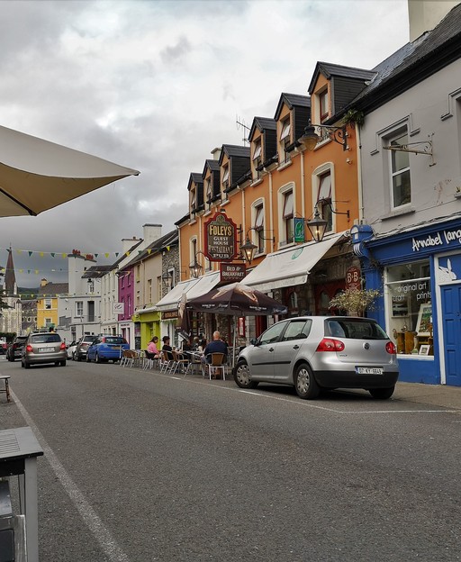
Kenmare is a small town at the head of Kenmare Bay, between the Iveragh and Beara peninsulas, with 2,566 people at the 2022 Census. It suits retirees who want a walkable heritage town with mountains and water on the doorstep, as long as they are comfortable with a hospital that is about 65 km away. Source: CSO: Census 2022, table F1046 (population of towns); Discover Ireland: Kenmare.
Last checked: 20 November 2026. Every line below links to the page it came from. We give no prices (apart from one rent figure from the Residential Tenancies Board), fees or waiting times; check the official pages before you act.
Who Kenmare suits
Retirees: A heritage town of about 2,600 people with a stone circle, a bay and two peninsulas on the doorstep, and bus links to Killarney and West Cork. Source: CSO: Census 2022, table F1046 (population of towns); Kenmare.ie: Kenmare Tourism; Bus Éireann: route 270, Skibbereen to Killarney via Kenmare.
A story from Kenmare
The town’s Irish name is Ceann Mara, which its tourism site translates as ‘the head of the sea’, and which suits a heritage town on the shores of Kenmare Bay. Source: Kenmare.ie: Kenmare Tourism.
In the town itself stands Kenmare Stone Circle, which Discover Ireland describes as the only egg-shaped stone circle in Munster, measuring 17.4 by 15.8 metres; the circle’s own site dates it to the early Bronze Age. Source: Discover Ireland: Kenmare Stone Circle; Kenmare Stone Circle (site).
Hospital and airport
The nearest hospital with an HSE emergency department is University Hospital Kerry in Tralee, about 65 km by road (approximate). The HSE also lists a local injury unit, which is not an emergency department, at Bantry General Hospital, about 45 km away. Source: HSE: University Hospital Kerry Emergency Department (Find urgent and emergency care); HSE: Bantry Injury Unit; OpenStreetMap routing (OSRM): road distances, rounded to the nearest 5 km; OpenStreetMap (Nominatim): place coordinates.
Kerry Airport at Farranfore is about 50 km by road (approximate); Cork Airport is about 95 km. Source: Kerry Airport; OpenStreetMap routing (OSRM): road distances, rounded to the nearest 5 km; OpenStreetMap (Nominatim): place coordinates.
Getting around
Bus Éireann route 270 runs between Skibbereen and Killarney via Kenmare. Source: Bus Éireann: route 270, Skibbereen to Killarney via Kenmare.
TFI Local Link Kerry runs rural routes that serve Kenmare, including route 281 (Waterville to Kenmare) and route 282 (Castletownbere to Kenmare). Source: TFI Local Link Kerry: route 281, Waterville to Kenmare (leaflet); TFI Local Link Kerry: route 282, Castletownbere to Kenmare (leaflet).
Irish Rail’s station list has no station in Kenmare; Killarney is on the Dublin Heuston to Tralee line. Source: Iarnród Éireann: Find a station (full station list); Iarnród Éireann: Killarney station.
The setting and the weather
A coastal heritage town at the head of Kenmare Bay on the Wild Atlantic Way; Discover Ireland places it on the Ring of Kerry between the Iveragh and Beara peninsulas. Source: Discover Ireland: Kenmare; Kenmare.ie: Kenmare Tourism.
Met Éireann’s 1991-2020 averages for Valentia Observatory, the Kerry station in its series, give 1,646.5 mm of rain a year and about 250 rain days (days with 0.2 mm or more); Valentia is on the coast to the west. Source: Met Éireann: Valentia Observatory 1991-2020 averages; Met Éireann: Ireland’s Climate Averages 1991-2020.
Check live weather and the 7-day forecast for County Kerry.
What rent looks like
RTB Rent Index, Q1 2026, standardised average for new tenancies in County Kerry: €1,311 a month. This is a county average, not a figure for Kenmare alone. Source: RTB Rent Index, Q1 2026 (RTB/ESRI), new tenancies, standardised average rent by county; RTB: Tables for new tenancies, Q1 2026 (Table 16, county averages).
Your family’s county
If your family came from County Kerry, our County Kerry family records page shows what is online, from when, and where.
Things to do nearby
- Kenmare Stone Circle: A Bronze Age stone circle in the town, measuring 17.4 by 15.8 metres. Source: Discover Ireland: Kenmare Stone Circle; Kenmare Stone Circle (site).
- Kenmare.ie: the town’s tourism site: Describes the town as a base for the Ring of Kerry and the Beara Peninsula. Source: Kenmare.ie: Kenmare Tourism.
- The Kerry Way: A long-distance walking route on the Iveragh Peninsula, described by Discover Ireland. Source: Discover Ireland: Kerry Way.
Tours near Kenmare
- Full-Day Ring of Kerry Tour from Killarney (6.5 hours)
- Ring Of Kerry Tour (7.5 hours)
- NO 1 Ring of Kerry Tour inc Killarney Lakes & National Park (6 hours)
Tours are booked through Viator, and we may earn a commission at no extra cost to you. See all our tours.
More from us on Kenmare
- Living in County Kerry, Ireland: What Life Is Really Like
- Best Coastal Towns in Ireland: 10 Harbour Towns With Practical Tips
- Top 10 Things to Do in Kerry
Common questions
How big is Kenmare? The CSO’s Census 2022 gives Kenmare a population of 2,566. Source: CSO: Census 2022, table F1046 (population of towns).
Is there an emergency department in Kenmare? No. The nearest HSE emergency department is University Hospital Kerry in Tralee, about 65 km by road (approximate). Source: HSE: University Hospital Kerry Emergency Department (Find urgent and emergency care); OpenStreetMap routing (OSRM): road distances, rounded to the nearest 5 km.
Can I reach Kenmare without a car? Bus Éireann route 270 links Kenmare with Killarney and Skibbereen, and TFI Local Link Kerry routes 281 and 282 serve the surrounding area. Source: Bus Éireann: route 270, Skibbereen to Killarney via Kenmare; TFI Local Link Kerry: route 281, Waterville to Kenmare (leaflet); TFI Local Link Kerry: route 282, Castletownbere to Kenmare (leaflet).
This page is part of Live in Ireland. See also our housing, healthcare and first 90 days pages.
Sources
- CSO: Census 2022, table F1046 (population of towns)
- OpenStreetMap routing (OSRM): road distances, rounded to the nearest 5 km
- OpenStreetMap (Nominatim): place coordinates
- RTB Rent Index, Q1 2026 (RTB/ESRI), new tenancies, standardised average rent by county
- RTB: Tables for new tenancies, Q1 2026 (Table 16, county averages)
- Met Éireann: Ireland’s Climate Averages 1991-2020
- Discover Ireland: Kenmare
- Kenmare.ie: Kenmare Tourism
- Discover Ireland: Kenmare Stone Circle
- Kenmare Stone Circle (site)
- Discover Ireland: Kerry Way
- HSE: University Hospital Kerry Emergency Department (Find urgent and emergency care)
- HSE: Bantry Injury Unit
- Kerry Airport
- Bus Éireann: route 270, Skibbereen to Killarney via Kenmare
- TFI Local Link Kerry: route 281, Waterville to Kenmare (leaflet)
- TFI Local Link Kerry: route 282, Castletownbere to Kenmare (leaflet)
- Iarnród Éireann: Killarney station
- Met Éireann: Valentia Observatory 1991-2020 averages
- Iarnród Éireann: Find a station (full station list)