

Most people who drive to the Cliffs of Moher take the fastest route available. They follow the sat nav, arrive at the car park, pay their entry fee, and leave. But the coast road from Ennistymon to Liscannor — if you take it slowly — tells a different story about County Clare altogether.
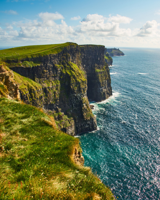
This route runs roughly 20 kilometres (about 12 miles) along the western edge of County Clare, hugging the Atlantic coast before arriving at the small fishing village of Liscannor, just south of the Cliffs. It is not a motorway. It is not always wide. But it is one of those roads that makes you glad you came to Ireland by car.
Here is what you need to know before you go.
The Route at a Glance
The drive begins in Ennistymon, a market town a few kilometres inland from the coast. From there, most drivers head west on the R481 to Lahinch, then south along the R478 coastal road to Liscannor. The total distance is around 20 km. Without stops, it takes under 30 minutes. With stops — and there are plenty of reasons to stop — allow two to three hours.
The road is well-signposted as part of the Wild Atlantic Way, Ireland’s long-distance coastal route. You will see the distinctive blue wave-and-horizon waymarkers throughout. If you are driving south from Galway, or arriving from the Aran Islands ferry at Doolin, this stretch fits well as an afternoon drive before continuing towards Kilrush or Kilkee.
Starting Point: Ennistymon
Ennistymon (in Irish, Inis Díomáin) sits on the River Inagh about 3 kilometres east of the coast. It is a working market town with a traditional main street — proper pubs, a hardware shop, a supermarket — rather than one arranged for tourists.
The most notable feature is the Cascades: a series of rocky falls on the River Inagh that run through the heart of the town and are visible from the bridge. After heavy rain, the water drops hard over the shelving limestone. It is worth five minutes of anyone’s time.
The Falls Hotel sits above the river and serves as the most prominent landmark. If you are beginning your drive in the morning, the cafés on the main street open early. Eat before you head west — food options thin out once you are on the coast road proper.
Lahinch — The First Stop
The R481 from Ennistymon brings you to Lahinch in about five minutes. Lahinch is a small town with a large beach and an outsized reputation for surfing. The beach faces west into the Atlantic, and the swell that arrives off the open ocean makes it one of the most consistent surf breaks on the Irish coast.
Surf schools operate here from spring through to early autumn. A two-hour beginner lesson typically costs around €35–€45 per person, with equipment included. The beach has free parking along the promenade.
Lahinch Golf Club, established in 1892, occupies the dunes to the north of town. It is a links course — built on the narrow strip of coastal ground between the beach and the inland farmland — and international golfers travel specifically to play here. Book well in advance if that is on your agenda; it fills up months ahead in summer.
Away from the beach, Lahinch has a reasonable range of cafés, pubs, and takeaways. This is the right place to fill a flask and pick up food before heading south.
Want more guides like this, straight to your inbox? The Love Ireland newsletter covers practical travel ideas for Ireland — where to go, when to go, and what the guidebooks leave out. Subscribe free at loveireland.substack.com.
The Road South to Liscannor
Once you leave Lahinch heading south, the character of the drive changes. The R478 climbs slightly above the coast and the views open out across Liscannor Bay. The land here is a mix of low stone walls, rough grazing, and cliff-edge fields that drop away into the Atlantic.
This is the stretch to slow down on. The road is narrow enough in places that passing a touring coach requires patience on both sides. There are pull-in points where you can stop and look out across the bay — use them. The sound of the sea and the scale of the Atlantic at this latitude are hard to convey in photographs.
About halfway between Lahinch and Liscannor, a turn-off leads to Hag’s Head (Ceann Caillí), the southernmost headland before the Cliffs of Moher begin. The Irish name refers to the hag, a figure from local mythology associated with the landscape. The headland gives an unobstructed view of the cliffs stretching north — and almost nobody is there.
Consider that contrast: the main Cliffs of Moher visitor centre draws around 1.5 million people per year. Hag’s Head, which gives you an equally dramatic view of the same cliffs from the south, has a small free car park and a short walk to the edge. The ruins of a tower near the tip are the remains of Moher Tower, a Napoleonic-era watchtower built around 1808 — not to be confused with the better-known O’Brien’s Tower near the main visitor centre, which dates from 1835. The ground can be soft after rain, so boots or sturdy shoes help.
Arriving at Liscannor
Liscannor is a small village with a pier, a scatter of houses, and a pub that has been a fixture here for generations: Vaughan’s Anchor Inn. The population is a few hundred. In summer it gets busy as a stopping point before or after the Cliffs, but it keeps the quiet rhythm of a working coastal community.
One thing worth knowing: Liscannor is the birthplace of John Philip Holland, born here in 1841, who went on to design the first submarine commissioned by the United States Navy. There is a small plaque commemorating him in the village. It is not a major attraction, but it is the kind of detail that makes a place feel real rather than just photogenic.
Just outside the village, signed from the main road, is St Brigid’s Well (Tobar Bhríde). This holy well is associated with St Brigid of Kildare, one of Ireland’s three patron saints, and has been a pilgrimage site for centuries. People leave offerings — photographs, rosary beads, handwritten notes — on the surrounding shrine. Whether you are religious or not, the site is genuinely affecting. It is accessible year-round at no cost.
The pier at Liscannor looks out over the bay. It is an ordinary working pier rather than a tourist attraction, but it is a good place to stop and take in the scale of the coast you have just driven through.
Planning a trip to County Clare? The Love Ireland newsletter covers the practical side of visiting Ireland — from coastal drives to hidden heritage sites. Sign up free at loveireland.substack.com.
Where to Eat and Drink Along the Way
Options along the route are concentrated in Lahinch and Liscannor. In Lahinch, the Blue Diner on the main street does solid café food, and Barrtra Seafood Restaurant — a short drive inland towards Ennistymon — is well regarded for evening meals. In Liscannor, Vaughan’s Anchor Inn serves food throughout the day and is noted for its fish dishes, which makes sense given where you are sitting.
If you are making a full day of it and continuing north to the Cliffs of Moher and on to Doolin, there are further options in Doolin itself — Gus O’Connor’s pub being the most famous, with traditional music sessions most evenings.
Practical Tips for the Drive
- Best time: Early morning, particularly in July and August, avoids the heaviest traffic around Lahinch and the Cliffs of Moher car park.
- Road condition: The coastal road is in reasonable condition but narrow in stretches. Drive slowly and use passing places generously.
- Fuel: Fill up in Ennistymon or Lahinch. There is no petrol station between Lahinch and Liscannor.
- Parking: Lahinch has paid parking along the promenade. Hag’s Head has a small free car park. Liscannor has informal parking near the pier.
- Cliffs of Moher: If you plan to visit the main site, advance booking for the car park is strongly recommended in peak season. Admission is charged per person, not per car — adult tickets run from around €15 when booked online for off-peak arrival — and parking is included in that fee.
- Public transport: Bus Éireann route 350 connects Ennis to Lahinch and Liscannor, but services are infrequent. A car is the practical option for this route.
- Weather: Check the forecast. Rain does not make the drive unpleasant, but sea spray and low cloud affect visibility at the headlands. A clear morning in any season is worth waiting for.
A Road Worth Taking Slowly
The Ennistymon to Liscannor coast road is not the main event for most visitors to County Clare. The Cliffs of Moher hold that title. But the road that leads to them — if you give it the time it deserves — is one of the more quietly satisfying drives in Ireland. You see the coast at eye level, at your own pace, without a visitor centre telling you where to stand.
That is harder to find than it sounds.
Get the best of Ireland in your inbox. The Love Ireland newsletter is free, practical, and written for people who want to explore Ireland properly. Subscribe at loveireland.substack.com.
County Clare was one of the hardest-hit counties during the Great Famine — the coastline you’re reading about saw families board emigrant ships from nearby ports in the 1840s and 1850s. If your family name connects to Clare, our free Irish Ancestral Heritage Guide includes county-specific emigration records, Griffith’s Valuation data, and townland maps for Clare and the west of Ireland. Trace your Clare ancestors here — free.
☘️ Join 64,000+ Ireland Lovers
Every weekday morning, get Ireland’s hidden gems, local secrets, and travel inspiration — the kind you won’t find in any guidebook.
Subscribe free — enter your email:
📲 Know someone who’d love this? Share on WhatsApp →
Love more? Join 43,000 Scotland lovers → · Join 29,000 Italy lovers → · Join 7,000 France lovers →
Free forever · Unsubscribe anytime
Tours & experiences you might love


Powered by Viator. Some links are affiliate links — we may earn a small commission at no extra cost to you.
Secure Your Dream Irish Experience Before It’s Gone!
Planning a trip to Ireland? Don’t let sold-out tours or packed attractions spoil your journey. Iconic experiences like visiting the Cliffs of Moher, exploring the Rock of Cashel, or enjoying a guided walk through Ireland’s ancient past often sell out quickly—especially during peak travel seasons.

Booking in advance guarantees your place and ensures you can fully immerse yourself in the rich culture and breathtaking scenery without stress or disappointment. You’ll also free up time to explore Ireland’s hidden gems and savour those authentic moments that make your trip truly special.
Make the most of your journey—start planning today and secure those must-do experiences before they’re gone!