

Ireland Has a Beach Called Murder Hole. Nobody Agrees on Why.
In the summer of 2021, a beach that most people in Ireland had never heard of began attracting more than five thousand visitors a day. It had no lifeguard. No road to the waterline. No swimming, ever. It was reached by a steep unmarked path through rough Atlantic headland. And it was called Murder Hole.
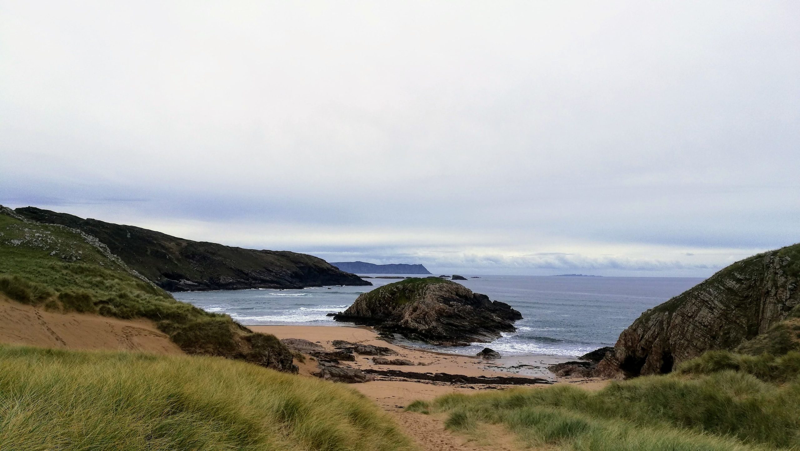
The photographs that started the rush — the ones that kept appearing on Instagram feeds and Facebook travel groups — all showed the same thing: a small cove of white sand, water the colour of a swimming pool, enclosed on three sides by dark rocky headland. It looked wrong in the best possible way. People shared the images. People questioned where they had been taken. Then people drove to Donegal to verify them in person, and things got complicated.
A new dedicated car park and waymarked trail were opened at Melmore Head in response to the congestion, established around April 2022. The beach had been doing fine — uncrowded, locally loved, occasionally visited by those who knew where to look — for as long as anyone could remember. Two years of viral photography changed the equation entirely. A place that had previously needed no infrastructure found itself requiring management.
Finding it, which is part of the point
Murder Hole Beach (its official Irish-language designation is Bá Íochtair, which we’ll come back to) sits near the tip of the Rosguill Peninsula in the far north of County Donegal, just below Melmore Head. Downings — the nearest village worth the name — is roughly 8 kilometres to the south. Getting there means taking the Atlantic Drive north from Carrigart, looping along the peninsula’s perimeter through Downings, and continuing toward the headland.
The practical starting point for most visitors is the car park at Melmore Family Caravan Park, where parking costs around €5. From there, a signed trail drops toward the beach — steep, uneven, exposed, and taking most walkers somewhere between fifteen and twenty-five minutes each way. There is an alternative approach from Trá na Rossan further south, but it adds considerable distance, running closer to forty minutes in each direction. Neither route involves anything technically demanding, but “easy coastal walk” would be misleading. We’d call it purposeful walking: rough ground, real gradient, no handrails. For turn-by-turn directions and more on parking, see our full Murder Hole Beach visitor guide.
That gap between car and beach — the steep drop, the effort, the sense of working toward something — is entirely part of what makes the arrival feel like it means something. The cove does not reveal itself until you’re almost at the bottom of the path. One moment you’re on a headland with the full Atlantic visible in all directions; the next you’re standing on white sand looking at water that appears, in the right light, to belong somewhere considerably further south on the globe.
What the Irish name actually says
Here is the detail that most travel coverage of this beach glosses over: the name “Murder Hole” is English, and relatively recent in the way place names go. The beach’s official Irish designation — as recorded by logainm.ie, Ireland’s state authority for place names — is Bá Íochtair. The etymology is unglamorous: bá means “bay,” and íochtar means “lower” or “northern.” So Bá Íochtair is, depending on how you translate the directional, either Lower Bay or Northern Bay. That is the name that carried the real linguistic memory of this place through centuries of daily use.
The anglicised versions — Boyeeghter Bay, Boyeeghter Strand — appear on the official signage. They do not travel well on social media. “Murder Hole” does.
So where did the English name come from? Two folk theories circulate, and it is worth being precise about what we know: neither has been verified by any primary historical source. The more vivid story involves an unnamed young woman who fell from the cliffs near the beach in the nineteenth century, and local memory settling on the location with a name that carried the weight of that. The second theory — simpler, perhaps more useful — points to the water itself. The riptides and undercurrents in this cove are powerful and dangerous, driving in from multiple angles, and “Murder Hole” as a functional warning label might simply reflect what local people had long understood about the sea here.
Attempt to find documentary evidence for either story — a newspaper account, a folklore commission record, a coroner’s filing — and you come up empty. Wikipedia presents both theories with identical hedging language. The Irish name, which would encode the genuine etymological memory of the place, contains no reference to violence, danger, or any historical incident. The origin of the name is, genuinely, unresolved. That uncertainty turns out to be more durable — and more shareable — than a clean explanation would have been. The beach named itself perfectly for the age of viral content without anyone planning it that way.
The water, and what to believe about it
Every visitor account we’ve found describes the water at Murder Hole as unexpectedly clear and blue-green. The “Caribbean” comparison appears across dozens of travel posts and social media captions, usually written by people who have just come back from the beach and are still slightly surprised by what they saw.
The comparison is exaggerated, and it would be doing you a disservice to let it stand unchallenged. The North Atlantic off the Rosguill Peninsula is cold — Donegal in summer means water temperatures well below anything you would encounter in the Caribbean or the Mediterranean. What the beach genuinely offers is visual clarity rather than tropical warmth: white sand in a sheltered cove, shallow clean Atlantic water arriving without significant river run-off or industrial discharge in the surrounding landscape, and — on a good summer day with strong light — a quality of colour that does not look like the standard expectation for the northwest Irish coast.
On a grey Donegal day, which is most days from October through April and a reasonable proportion of the summer too, the cove looks exactly like what it is: a remote Atlantic beach in the northwest of Ireland, beautiful on its own terms without requiring comparison to anywhere else. The photographs that circulated in 2021 — the ones that triggered the visitor rush — were taken on days when all the conditions aligned: strong sun, calm sea, the water at its clearest. Those conditions are real. They do occur. They are not the default. Anyone planning a trip specifically around the Caribbean-comparison photographs should build in enough flexibility to wait for the right day, or make peace with whichever version of the beach Donegal decides to provide.
The one rule that is non-negotiable
Murder Hole Beach is not a swimming beach. This is consistent, unanimous, and not hedged across every source that covers it — the official Wild Atlantic Way listings, the Irish Beach Guide, Donegal Beaches, Wikipedia, and the accumulated TripAdvisor reviews stretching across multiple years say the same thing without variation. The riptides and undercurrents here are dangerous. There is no lifeguard service of any kind. Wikipedia records a specific incident in which a girl was swept out to sea.
The sea cave at the edge of the cove — one of the beach’s genuine draws — is accessible only at low tide. As the tide rises, water enters from both sides of the beach simultaneously, moving faster than it might appear from higher ground. Being inside the cave when the tide turns is a situation that has gone badly for people before and will go badly again for people who underestimate how quickly the Atlantic reorganises itself.
Tide-checking before you leave the house is not a precaution but a prerequisite. Met Éireann publishes tide tables for the Donegal coast, and various marine apps carry the same information. Plan your arrival around low tide — the beach opens up, the cave is accessible, and the full cove shows itself properly. Arrive at high tide and you may find the beach substantially reduced, with nowhere comfortable to stand and none of the cave access that makes the place worth the hike.
When to go, and a word about what to expect
The obvious answer is summer — the months when the light is strongest and the odds of catching the beach in its most striking conditions are highest. But summer 2021 demonstrated what happens when thousands of people arrive at the same logical answer simultaneously. More than five thousand visitors a day on a beach served by a single steep track and a small car park meant queues, a footpath worn to mud in places, and a cove that felt considerably less remote than the photographs had suggested.
May and September offer a different proposition. The crowds thin considerably, the light can still be excellent in either shoulder of summer, and the experience of arriving at a cove that requires genuine effort to reach — and finding it mostly to yourself — is closer to what prompted people to talk about this place before it went viral. The peninsula road is quieter in the shoulder season. The car park is manageable. The walk down to the beach feels like its own thing again, rather than a queue with scenery attached. For more of the county beyond this one beach, see our guide to the best things to do in Donegal.
The Rosguill Peninsula as a whole earns more than the minimum amount of time. The Atlantic Drive that circumnavigates the peninsula is one of the quieter coastal routes in this part of Donegal — real headland, real views, the kind of landscape that carries its own explanations for why people wrote so much about this part of the country. Murder Hole is the dramatic punctuation at the end of the loop. The drive to reach it is worth taking slowly.
What you’re actually signing up for
Let us try to draw an accurate picture. You drive to a car park in the far north of Donegal, pay a few euros, and walk a steep trail for twenty-odd minutes. At the bottom is a cove of white sand, enclosed by dark Atlantic headland, with water that — if the conditions cooperate — turns a genuinely unexpected shade of blue-green. There is no café. No facilities. No swimming. The sea cave requires a low tide. The weather is Donegal’s to determine. The name may come from a death, or from the sea’s own habits, or from something history has simply lost track of.
It is, apparently, enough. More than five thousand people a day found it enough in one summer, without any of the infrastructure we usually associate with a popular beach destination. The walk, the effort, the name that keeps needing explanation, the water that surprises you by being that colour — all of it is part of what this place is. The beaches that make you work to reach them tend to stay with you longer than the ones with car parks right at the sand’s edge.
Wear proper shoes for rough ground. Check the tide before you set off. Leave the swimming for somewhere with a lifeguard on duty. If the light is with you when you arrive, take the photograph — it will not need much help to look like somewhere it isn’t.
Tours & experiences you might love


Powered by Viator. Some links are affiliate links — we may earn a small commission at no extra cost to you.
Secure Your Dream Irish Experience Before It’s Gone!
Planning a trip to Ireland? Don’t let sold-out tours or packed attractions spoil your journey. Iconic experiences like visiting the Cliffs of Moher, exploring the Rock of Cashel, or enjoying a guided walk through Ireland’s ancient past often sell out quickly—especially during peak travel seasons.

Booking in advance guarantees your place and ensures you can fully immerse yourself in the rich culture and breathtaking scenery without stress or disappointment. You’ll also free up time to explore Ireland’s hidden gems and savour those authentic moments that make your trip truly special.
Make the most of your journey—start planning today and secure those must-do experiences before they’re gone!