

Someone recently asked a question on our Facebook page that stopped us in our tracks: “If you had to describe Ireland’s shape to someone who’d never seen a map, what would you say?”
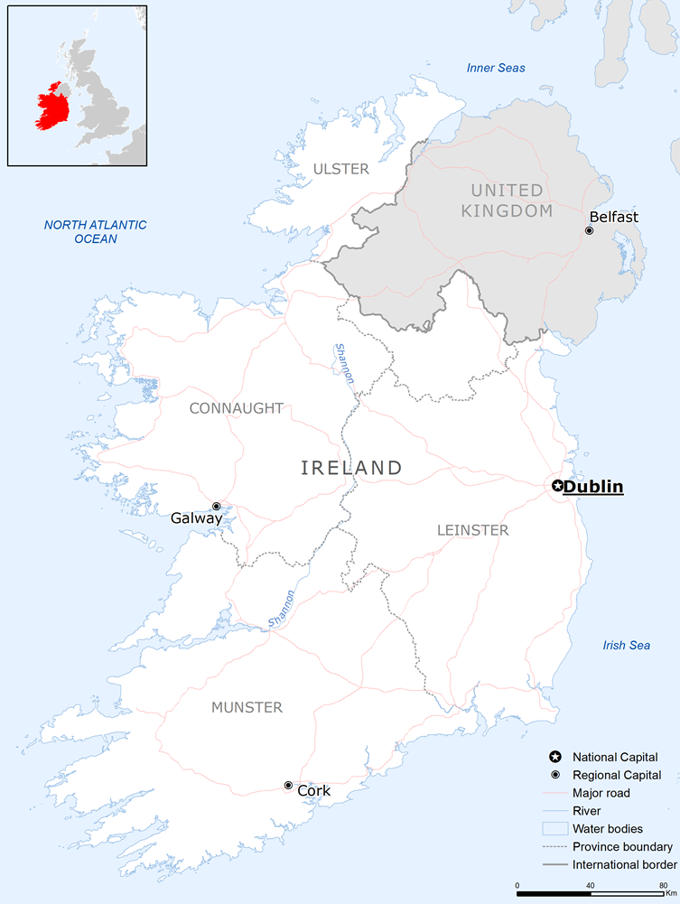
It’s deceptively tricky. Most of us have looked at a map of Ireland hundreds of times, yet the moment you try to put that shape into words, the words disappear. You end up waving your hands around and saying something like, “Well, it’s sort of… lumpy on the left side.”
This article is an attempt to actually answer that question properly — with facts, dimensions, and some comparisons that genuinely help.
Want more like this? Our free newsletter covers Irish geography, history, culture, and travel — delivered to your inbox. Subscribe to the Love Ireland newsletter here.
The Basic Outline
Ireland is an island located off the northwest coast of Europe, separated from Britain by the Irish Sea to the east. It is the third-largest island in Europe and the twentieth-largest in the world, with a total land area of around 84,421 square kilometres (32,595 square miles).
In very simple terms, the island is roughly oval — but an oval that has been pushed and pulled in different directions depending on which side you’re looking at. The eastern coastline, which faces Britain, is relatively calm and smooth. The western coastline, which faces the open Atlantic Ocean, is dramatically ragged, cut up by deep bays, jutting headlands, and long peninsulas that stretch out into the sea.
That east-west contrast is the single most important thing to understand about Ireland’s shape. The eastern side is where you find Dublin and the main population centres. The western side is where the landscape becomes wilder and the coastline starts to look like it’s been torn rather than drawn.
🇮🇪 Plan Your Perfect Ireland Trip
Join 64,000 Ireland lovers. Get weekly travel inspiration, hidden gems and local secrets — free every weekday.
Ireland’s Dimensions in Plain Numbers
If you want something concrete to hold on to, here are the numbers:
- North to south: approximately 486 kilometres (302 miles) — from Malin Head in County Donegal to Mizen Head in County Cork
- East to west: approximately 275 kilometres (171 miles) at the widest point
- Total coastline: approximately 2,500 kilometres (1,550 miles)
- Total area: 84,421 square kilometres — slightly larger than the island of Hispaniola in the Caribbean, and a little smaller than the US state of Indiana
Those coastline numbers are worth pausing on. For an island of its size, 2,500 kilometres of coastline is a very high ratio. It tells you that Ireland’s edges are not clean or simple — they are deeply indented and complex, especially on the western seaboard.
The island’s highest point is Carrauntoohil in County Kerry at 1,038 metres (3,406 feet), and it sits in the southwest — part of the mountain country that defines the feel of that region. Ireland is not a flat island. It has a central lowland surrounded by coastal uplands, which is one reason why so much of the country’s population has historically lived near the coasts and river valleys.
The East Coast Versus the West Coast
The difference between Ireland’s two coastlines is striking enough to be worth its own section.
The east coast — from County Louth in the north to County Wexford in the south — runs in a fairly orderly line. There are beaches, harbours, and some indentations, but nothing dramatic. Dublin Bay is the most significant feature, a broad, south-facing bay that has made Dublin a natural port city for over a thousand years.
The west coast is an entirely different story. Starting from County Donegal in the northwest and working your way south through Mayo, Galway, Clare, Kerry, and Cork, the coastline becomes increasingly chaotic in the best possible way. Clew Bay in County Mayo is said to contain 365 islands — one for every day of the year, according to local tradition. Clew Bay alone gives you an idea of how deeply fragmented this coastline is.
The reason for this difference is geology and the direction of Atlantic weather systems. Over millions of years, ocean waves driven by prevailing westerly winds have carved the western coast into the intricate shape it has today. The east, sheltered by Britain, has not experienced the same erosive force.
The Peninsulas That Define the Southwest
If you were to describe Ireland’s shape to someone, the southwestern corner would require the most explanation — because that is where the island becomes most unusual.
County Kerry and County Cork together form a series of long, finger-like peninsulas that point southwestward into the Atlantic. These are among the most recognisable features of Ireland’s outline:
- The Dingle Peninsula (An Daingean): The most northerly of Kerry’s great peninsulas, stretching about 50 kilometres into the ocean and home to some of the finest scenery in the country
- The Iveragh Peninsula: The largest of the Kerry peninsulas, famous for the Ring of Kerry route that encircles it — approximately 179 kilometres of road around a single landmass
- The Beara Peninsula: Shared between Kerry and Cork, this long, narrow strip of land reaches nearly 50 kilometres into the Atlantic
- The Mizen and Sheep’s Head Peninsulas: Further west in Cork, these narrow spits of land give the southwestern tip of Ireland its distinctive claw-like appearance on the map
These peninsulas are the main reason why Ireland’s total coastline is so long relative to its overall size. Each peninsula adds two coasts — a northern shore and a southern shore — and Ireland has a lot of them.
Curious about Ireland’s geography, history, and best places to visit? Our free weekly newsletter goes deeper on all of it. Join thousands of readers — subscribe here.
How the Four Provinces Help You Picture It
Ireland is divided into four historic provinces, and knowing roughly where each one sits is a useful mental map for anyone trying to picture the island’s layout:
- Leinster covers the east and southeast — Dublin is here, along with counties like Wicklow, Wexford, Kilkenny, and Kildare. This is the most densely populated quadrant of the island.
- Munster covers the south and southwest — Cork, Kerry, Limerick, Tipperary, Clare, and Waterford. This is where you find the famous peninsulas and much of the country’s most dramatic scenery.
- Connacht covers the west — Galway, Mayo, Sligo, Roscommon, and Leitrim. The Connemara region of Galway, in particular, gives you a sense of just how remote and rugged the western interior can be.
- Ulster covers the north — nine counties in total, six of which make up Northern Ireland (part of the United Kingdom) and three of which (Donegal, Cavan, Monaghan) are part of the Republic. This is where the border runs, cutting across the province.
If you place those four provinces in your mind — east, south, west, north — you have a rough but workable mental map of the island.
The Comparisons People Actually Use
So what do people actually say when they try to describe Ireland’s shape?
The most common answer is a teddy bear — and once you’ve heard it, you cannot unsee it. The broad top of the island (Ulster) becomes the head, the slight narrowing in the middle is the neck, and the wider southern provinces form the body. It is not a precise comparison, but it captures the general outline better than most alternatives.
Some people say it looks like a sleeping dog or a lamb facing left. Others describe it as a rough triangle with its point at the southwest, which is accurate in a very general sense — the island does taper as you head toward County Kerry.
A more geographic answer: Ireland looks like a slightly squashed oval, broader at the top than the bottom, with a smooth right side (the east) and a jagged, heavily indented left side (the west). The southwestern corner looks like it has had chunks pulled out of it by the ocean — which is essentially what happened over millions of years.
If you are talking to someone who knows the UK, a useful comparison is that Ireland is roughly 40 percent the size of Britain, positioned directly to Britain’s west, and its eastern coast runs roughly parallel to Britain’s western coast.
Key Geographic Reference Points
For anyone who wants specific anchors to describe the shape, these are Ireland’s four extreme points:
- Northernmost point: Malin Head, County Donegal — a rugged headland that is the very top of the island and one of the northern highlights of the Wild Atlantic Way
- Southernmost point: Mizen Head, County Cork — a dramatic headland with towering sea cliffs on the Wild Atlantic Way route (the road’s official southern terminus is Kinsale, a little further along the coast)
- Easternmost point: Burr Point, County Down — a low headland on the Ards Peninsula that marks the eastern tip of the whole island (Wicklow Head, County Wicklow, is the easternmost point of the Republic of Ireland specifically). The narrowest crossing to Britain is further north, where Torr Head in County Antrim sits just 19 kilometres from Scotland’s Mull of Kintyre.
- Westernmost point: Dunmore Head on the Dingle Peninsula, County Kerry — the nearest Irish landmass to North America
Draw lines between those four points and you have a rough bounding box that contains the whole island. Within that box, the eastern edge is filled almost to the boundary, while the western edge — particularly in the southwest — retreats well inward before those peninsulas reach out again.
What the Shape Tells You About Travelling Ireland
Understanding Ireland’s shape has practical value for anyone planning a visit.
The country is small enough that you could theoretically drive from Dublin on the east coast to Dingle on the west coast in around four hours on a good day. But “a good day” is doing a lot of work in that sentence. Irish roads are not motorways all the way through, and the country’s shape — particularly those long peninsulas — means that detours can add significant time and distance.
The Ring of Kerry is a famous example. The Iveragh Peninsula looks like a manageable loop on the map, but driving the full 179-kilometre circuit, with stops, can comfortably fill a full day. The same is true of the Dingle Peninsula. The shape of the island means you spend more time in the southwest than a glance at the map might suggest.
The north-south route, from Dublin to Donegal or Dublin to Cork, is also longer in practice than it appears. Roads improve year by year, but Ireland is not a country where distances translate simply into journey times. Factor in a third more time than you think you will need, and you will rarely go wrong.
One more practical note: because of the way the island narrows toward the north and broadens in the south, the journey from Dublin to Galway (across the middle of the island, roughly 220 kilometres) feels longer than the east-to-west dimension might suggest. County Galway, despite being on the west coast, still requires crossing the central lowlands, and those roads can be slow in places.
None of this is a reason to rush. Ireland’s geography rewards slow travel. The peninsulas that make the southwest so complex on a map are exactly the places where the scenery is most rewarding. The indentations and detours are where you find the coves, the cliff views, and the villages that make a trip to Ireland memorable.
Get more practical Ireland content — geography, travel tips, history, and local knowledge — delivered free to your inbox every week. Subscribe to the Love Ireland newsletter.
The Short Answer
If you truly need to describe Ireland’s shape in one sentence to someone who has never seen a map, here is a reasonable attempt:
Ireland is a roughly oval island, smooth on the eastern side and deeply indented on the west, with a series of long peninsulas pointing into the Atlantic from the southwestern corner — about the size of Indiana, and just small enough that you can drive from one end to the other in a day, if you do not stop too often.
The last part, of course, is the hard part. In Ireland, stopping too often is the whole point.
☘️ Join 64,000+ Ireland Lovers
Every weekday morning, get Ireland’s hidden gems, local secrets, and travel inspiration — the kind you won’t find in any guidebook.
Subscribe free — enter your email:
📲 Know someone who’d love this? Share on WhatsApp →
Love more? Join 43,000 Scotland lovers → · Join 29,000 Italy lovers → · Join 7,000 France lovers →
Free forever · Unsubscribe anytime
Tours & experiences you might love


Powered by Viator. Some links are affiliate links — we may earn a small commission at no extra cost to you.
Secure Your Dream Irish Experience Before It’s Gone!
Planning a trip to Ireland? Don’t let sold-out tours or packed attractions spoil your journey. Iconic experiences like visiting the Cliffs of Moher, exploring the Rock of Cashel, or enjoying a guided walk through Ireland’s ancient past often sell out quickly—especially during peak travel seasons.

Booking in advance guarantees your place and ensures you can fully immerse yourself in the rich culture and breathtaking scenery without stress or disappointment. You’ll also free up time to explore Ireland’s hidden gems and savour those authentic moments that make your trip truly special.
Make the most of your journey—start planning today and secure those must-do experiences before they’re gone!