

The Gleniff Horseshoe is a 10-kilometre loop road in County Sligo that circles a dramatic mountain valley in the Dartry Mountains. It receives a fraction of the visitors that the Cliffs of Moher or the Ring of Kerry attract, but it offers something those more famous routes cannot: genuine solitude among extraordinary scenery.
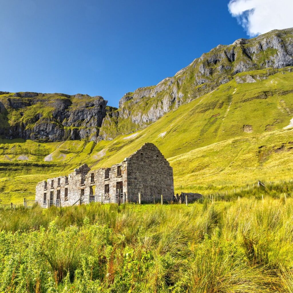
This guide tells you exactly what to expect on the drive, how to get there, and what else to see while you are in this part of the west of Ireland.
Get Ireland travel stories every week — free.
Subscribe to the Love Ireland newsletter →
What Is the Gleniff Horseshoe Drive?
The Gleniff Horseshoe is a circular road that loops through the Gleniff Valley, a glacially-carved valley beneath the Dartry Mountains in north County Sligo. The route gets its name from the horseshoe shape the road traces as it follows the valley floor and climbs partway up the surrounding hillsides.
The total length is around 10 kilometres. The road passes beneath sheer limestone cliffs and through open farmland before returning to the starting point. At its deepest point, the cliffs rise steeply on three sides, giving a strong sense of enclosure that few other Irish drives can match.
The Dartry Mountains, which frame this valley, include some of the highest ground in County Sligo. Truskmore — the county’s highest peak at 647 metres — sits at the eastern edge of this range. Benwiskin and Benbulben (further south) are part of the same geological formation: a series of flat-topped limestone plateaux that are unique to this corner of Ireland. The rock layers were laid down roughly 300 million years ago and shaped into their current form by glaciers during the last ice age.
How to Get There
☘️ Your Irish family has a story waiting to be found.
Discover where your Irish ancestors came from — their county, their name, their story. Our free step-by-step guide walks you through every record, DNA tool, and ancestry archive. No experience needed.
Claim Your Free Irish Ancestry Guide →The Gleniff Horseshoe is located approximately 20 kilometres north of Sligo town, close to the village of Glencar. To drive there from Sligo, take the N15 north towards Bundoran for around 10 kilometres, then turn right onto the R286 towards Manorhamilton. After passing through Glencar village, follow the sign for the Gleniff Horseshoe. The turn-off is clearly marked on the roadside.
If you are coming from Bundoran or south Donegal, head south on the N15 and turn left onto the R286 before reaching Sligo town.
There is a small car park at the entrance to the route. Parking is free. The road itself is tarmacked throughout but narrows to single track in places, so drive carefully and use passing bays when meeting oncoming vehicles. Large motorhomes and campervans may find some sections awkward.
What to Expect on the Drive
The Gleniff Horseshoe is primarily a driving route. The road takes you through terrain that would take hours to cover on foot. That said, there are several points where you can park on the verge and walk further into the valley.
The first section follows the valley floor through fields at the base of the cliffs. The limestone faces here are steep and impressive — streaked with water in wet weather, which in this part of Sligo is most of the year. The cliffs shelter the valley from the prevailing westerly winds, and the valley floor feels noticeably calmer than the exposed terrain outside it.
As the road climbs around the head of the horseshoe, the views open out significantly. You can look back down the valley towards Glencar Lake and, on a clear day, westward towards the Atlantic coast. The descent on the far side brings you back to flatter ground and the main road.
The full loop takes around 30 to 45 minutes by car if you stop at the main viewpoints. Allow longer if you plan to walk any section of the valley. In July and August the route sees its heaviest traffic, but even then it is significantly quieter than comparable drives further south. Visit in April, May, September, or October and you may have the valley largely to yourself.
Wildlife and Natural Features
The Gleniff Valley is a limestone karst landscape. The cliffs support populations of peregrine falcon, which use the high ledges for nesting. Ravens are common year-round. You may also see red kite — a bird successfully reintroduced to Ireland from Wales in the 2000s — and chough, a red-billed crow associated with coastal cliffs in Ireland.
The boggy ground on the valley floor and lower hillsides supports the typical plant communities of western Irish uplands: bog cotton, heather, purple moor grass, and a range of mosses and liverworts. Small streams run off the cliff faces throughout the year, with the flow at its heaviest after prolonged rainfall.
County Sligo receives around 1,200 millimetres of rainfall annually, with the wettest months between October and March. That said, Sligo weather is unpredictable in any season. Bring a waterproof layer regardless of the forecast.
Stories like this, straight to your inbox.
Join thousands of readers — subscribe free →
Glencar Waterfall — A Short Detour Worth Making
Less than two kilometres from the Gleniff Horseshoe junction, Glencar Lake sits at the foot of the Dartry Mountains. On the northern shore of the lake, the Glencar Waterfall drops around 15 metres into a rock pool below. It is sign-posted from the R286 and accessible via a short, well-maintained path of about 400 metres return from the car park.
The waterfall features in W.B. Yeats’s poem The Stolen Child, published in 1886. Yeats references “the sleepy water” near where “the wandering water gushes / From the hills above Glen-Car” — the valley is recognisable from the description even now. The car park has a wooden viewing platform that positions you directly in front of the falls. The walk is suitable for most fitness levels and takes around 20 minutes return. Parking is free.
W.B. Yeats and This Corner of Sligo
W.B. Yeats (1865–1939) spent much of his childhood in County Sligo and returned throughout his life. The landscape of north Sligo — Benbulben, Glencar, Knocknarea — runs through his poetry from his earliest published work to his final poems. His attachment to this particular part of Ireland was not sentimental but specific: he wrote about named places, named people, and named traditions.
Yeats is buried in the churchyard at Drumcliffe, roughly 12 kilometres south of the Gleniff Horseshoe on the N15. His grave is directly beneath Benbulben. The headstone inscription — “Cast a cold eye / On life, on death. / Horseman, pass by!” — is taken from his poem Under Ben Bulben, written shortly before his death. The grave is a straightforward stop: the church is directly off the main road, the car park is free, and the walk to the grave takes under two minutes.
What Else to See in County Sligo
If you have a full day in the county, the following sites pair well with the Gleniff Horseshoe. For a broader look at the county’s highlights, see our complete guide to things to do in County Sligo.
Knocknarea: A prominent hill above Strandhill, topped by a large cairn known as Medb’s Cairn. The walk to the summit takes around 45 minutes and gives views across Sligo Bay and south towards Roscommon. The cairn — a massive mound of loose stones roughly 55 metres in diameter — has never been formally excavated and is believed to be the passage tomb of the legendary Queen Medb. The walk is steep in the final section but manageable for most people in reasonable fitness.
Strandhill: A small seaside village below Knocknarea. The beach is not suitable for swimming due to strong rip currents, but the long stretch of sand and Atlantic surf makes it a worthwhile stop. The village has a good selection of cafés and the Voya Seaweed Baths — a traditional seaweed bathing facility operating from a building near the shore.
Carrowmore Megalithic Cemetery: Located about 5 kilometres west of Sligo town, Carrowmore contains one of Ireland’s largest concentrations of megalithic monuments. Around 30 structures remain, including passage tombs and stone circles dating from approximately 5,000 to 6,000 years ago — making parts of the site older than Newgrange. Admission is charged (adult €5; check heritageireland.ie for current seasonal prices and opening hours). It receives far fewer visitors than comparable sites in the Boyne Valley.
Practical Tips
Best time to go: Spring (April and May) and early autumn (September and October) give the best combination of manageable weather and lighter traffic. The valley is striking after rain, when the streams on the cliff face run strongly.
Road conditions: Single-track in places. Drive slowly, use passing bays, and do not attempt to overtake on blind bends. Large vehicles should check the route in advance.
Facilities: No cafés, toilets, or shops within the valley. Stock up in Sligo town or Manorhamilton beforehand.
Getting there without a car: Public transport to the Gleniff Horseshoe is not practical. The nearest bus services reach Sligo town, from which you would need a hire car or taxi. The route is not accessible as a walk or cycle from the town.
What to wear: Waterproof jacket even in summer. Walking shoes if you plan to leave the car. The valley floor can be wet underfoot away from the road.
Photo: Shutterstock
Never miss an Ireland travel guide.
Subscribe to the Love Ireland newsletter — it’s free →
Thinking about it seriously?
If you’ve started actually planning a move, our complete the full Move to Ireland guide walks through every step, every cost, and the paperwork that catches most people out.
Tours & experiences you might love


Powered by Viator. Some links are affiliate links — we may earn a small commission at no extra cost to you.
Secure Your Dream Irish Experience Before It’s Gone!
Planning a trip to Ireland? Don’t let sold-out tours or packed attractions spoil your journey. Iconic experiences like visiting the Cliffs of Moher, exploring the Rock of Cashel, or enjoying a guided walk through Ireland’s ancient past often sell out quickly—especially during peak travel seasons.

Booking in advance guarantees your place and ensures you can fully immerse yourself in the rich culture and breathtaking scenery without stress or disappointment. You’ll also free up time to explore Ireland’s hidden gems and savour those authentic moments that make your trip truly special.
Make the most of your journey—start planning today and secure those must-do experiences before they’re gone!