

Hill of Tara: Why Did Ireland Build a Motorway Through Its Most Sacred Ancient Site?
In spring 2007, workers laying the groundwork for a new Irish motorway hit something unexpected in a field in County Meath. They uncovered a vast circular arrangement of timber posts — an outer ring stretching 80 metres across, an inner ring 16 metres wide, with an entrance avenue aligned to the rising of the Pleiades star cluster in the autumn sky. It was an Iron Age ceremonial enclosure, a pagan temple, at least 2,000 years old. Archaeologists who examined it said it was one of the most significant finds in Irish soil in years. Archaeology magazine later named it one of the ten most important discoveries in the world that year.
Six weeks after the find was announced, the Irish government signed an order to demolish it.
The site was called Lismullin. It sat roughly two kilometres from the Hill of Tara — the most mythologically charged piece of ground in Ireland, a hill whose continuous use as a sacred and political centre stretches back more than five thousand years. The motorway being built was the M3, a €680 million, 51-kilometre road designed to ease the Dublin-to-Navan commute. And the story of how those two things ended up in the same valley at the same time, and what happened when they collided, says something worth sitting with about how modern states value ancient places.
What Tara Actually Is
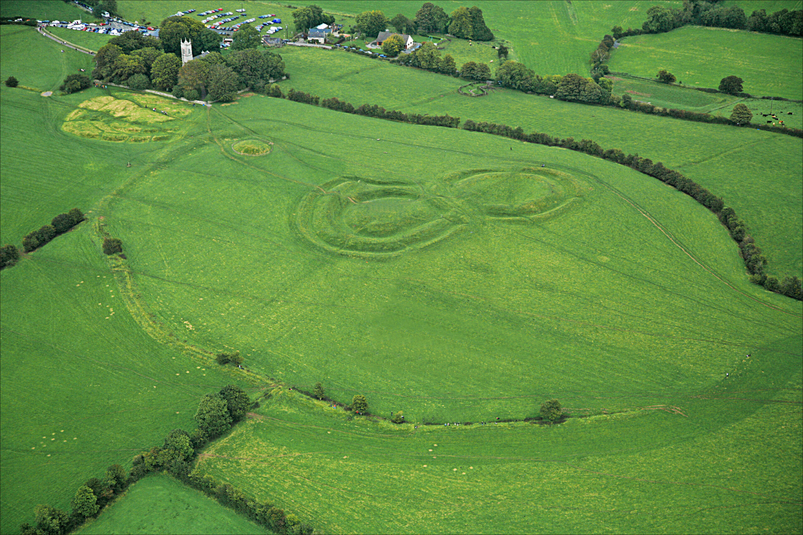
The Hill of Tara stands in the middle of County Meath, rising gently above the surrounding farmland to a height of around 154 metres. It is not a dramatic landscape by any measure — no cliffs, no crags. What it is, is loaded.
The oldest monument on the hill is the Mound of the Hostages, a megalithic passage tomb built around 3,200 BC. It held the cremated remains of nearly 300 people, interred over roughly a century in the Neolithic period, with a further 33 Bronze Age burials added in the millennia that followed. It is older than the Pyramids, built in the same era as its Boyne Valley neighbour, Newgrange. It is aligned to the ancient Celtic festivals of Samhain and Imbolc, catching the sunrise on the mornings of November 8th and February 4th.
That is just the oldest monument. There are at least 20 visible on the hill today. Ráith na Rí, the Fort of the Kings, is the largest — an enclosure with a circumference of roughly 1,000 metres, built around 100 BC. The Lia Fáil, the Stone of Destiny, stands on the King’s Seat, the legendary coronation stone of the High Kings of Ireland. There is an earthen feature known as the Banqueting Hall, a sunken road running north from the hill that may have been a ceremonial approach. Irish mythology holds that 142 kings reigned at Tara. It was the dwelling place of gods, the gateway to the otherworld. To hold the title of King of Tara was, according to UCD scholar Dr. Edel Bhreathnach, to claim “the kingship of the world” in the Irish sense — the supreme political and ritual authority on the island.
The wider landscape around the hill had always been assumed to matter too. But just how much was not fully understood until the 1990s.
The Maps Nobody Had
In 1992, Ireland’s Discovery Programme — a state-funded body established to survey and record the country’s ancient sites — began a systematic study of Tara and its surroundings. What they found changed the terms of the conversation about the site entirely.
Before that work, about 30 monuments were recorded on and around the hill. Geophysical surveys, aerial photography, and ground-level investigation expanded that number dramatically. By the time the Tara Research Project completed its major phases, the known monument count had grown to roughly 130. The surveys revealed that the Hill of Tara was not an isolated site but the centrepiece of a wider ritual and archaeological landscape — one that extended down into the valleys on either side, including the Tara-Skryne Valley to the south and east.
In other words: the hill was the obvious part. The valley was where much of the system lived.
This mattered enormously because by the late 1990s, plans were being drawn up for a new motorway through exactly that valley.
The Celtic Tiger Wants a Road
The National Roads Authority had been working on the route of the M3 for years. The N3 road linking Dublin to Navan was deteriorating under the strain of Ireland’s economic boom. A new dual carriageway, eventually upgraded to full motorway standard, was the proposed solution — a 60-kilometre route running from Clonee, near Dublin, up to Kells.
The Tara-Skryne Valley section was a known problem. Frank McDonald, writing in the Irish Times in 2004, reported that 141 archaeological sites had been identified along the entire route, with 42 of them concentrated in the Dunshaughlin-to-Dowdstown stretch — the section closest to Tara. That works out to one archaeological site on average every 370 metres. The cost of excavating all of them was estimated at a minimum of €30 million.
None of this stopped An Bord Pleanála from approving the M3 route in August 2003. The planning board granted its approval without attaching archaeological conditions.
More than 350 academics — archaeologists, historians, classicists — signed letters and statements opposing the chosen route. Professor George Eogan, who had spent 30 years excavating the nearby Neolithic complex at Knowth, was among the most prominent voices against it. Senator Maurice Hayes described the area as “a single archaeological environment which will be sundered and damaged irreparably.” Dr. Bhreathnach, in work published around this time, demonstrated systematically that Tara was not a standalone monument but the centrepiece of a wider sacred landscape — the very landscape the motorway was about to bisect.
Former Taoiseach John Bruton said it was “difficult to conceive of a route more likely to run into delays.” He was trying to be tactful. What he meant was that the valley was full of things that had not yet been found, and that finding them during construction was a terrible way to do archaeology.
Bertie Ahern, the actual Taoiseach at the time, was less circumspect. Dismissing the concerns of archaeologists and heritage groups, he said he couldn’t even see the Hill of Tara from where he was standing on the proposed route. This was, depending on your reading, either a confession that he had missed the point entirely or a compressed masterclass in political priorities.
What Happened When They Started Digging
Construction on the M3 began in spring 2006. By the time it was finished, crews had uncovered 38 new archaeological sites along the Tara-adjacent section alone — sites that had not been identified in the surveys used to justify the route’s approval.
Lismullin was found in spring 2007, in the fields below the hill. The enclosure had been invisible to the initial surveys. Its outer ring measured 80 metres in diameter. Its inner ring was 16 metres across. The posts that once formed its walls had long since rotted, but the holes where they stood remained. An entrance avenue suggested the structure had been deliberately oriented — a building with a purpose, not just a boundary. Research by Frank Prendergast would later establish that the avenue aligned with the rising of the Pleiades star cluster in the autumn night sky, connecting the structure to the agricultural rhythms of the Iron Age calendar.
The site was designated a National Monument shortly after its discovery. Campaigners, archaeologists, and heritage bodies called for the motorway route to be altered to preserve it. There was an alternative western route available that would have skirted the valley entirely. There were also proposals to restore the Navan-Clonsilla railway line, which had been closed in 1963, as an alternative to building a road at all.
None of those alternatives were taken up.
The Last Act of a Departing Minister
On June 12, 2007, the Minister for the Environment, Dick Roche, issued a direction under the National Monuments (Amendment) Act 2004. The direction was for the “preservation by record” of the Lismullin site — a phrase that sounds reassuring until you understand what it means. It means archaeologists were to document everything they could before the site was demolished to make way for the road. Record it, then destroy it.
It was one of Roche’s final acts in office. Ireland had just held a general election in May. Fianna Fáil lost three seats. The Green Party, holding steady at six seats, entered government for the first time as coalition partners. One of the Green Party’s incoming ministers, John Gormley, took over the Environment brief on June 14, 2007 — two days after Roche signed the demolition order.
Gormley said there was nothing he could do. The decision, he stated, could not be reversed.
Vincent Salafia, who led the campaign group TaraWatch, did not accept this. He outlined options for a judicial review, challenged the procedural compliance of the decision, and coordinated what had by then become an international campaign. The World Monuments Fund had placed Tara on its 2008 World Monuments Watch list of the 100 most endangered sites on the planet. UNESCO had formally expressed its concern. Writers, artists, and diaspora organisations in the United States were calling for the route to be reconsidered.
On September 23, 2007, more than 1,500 people gathered on the Hill of Tara and arranged themselves into a human sculpture — a harp, with the words SAVE TARA VALLEY spelled out across the hillside. It was a striking image. It changed nothing.
Brussels Notices
The European Commission launched infringement proceedings against Ireland over the Lismullin decision. The Commission’s position was that Ireland had failed to properly transpose EU environmental impact assessment directives — and that the demolition of a designated National Monument in the path of a road project was a particularly clear example of that failure. The Commission eventually brought the case to the European Court of Justice, arguing that Ireland had illegally demolished the Lismullin monument.
Ireland did not halt construction.
The M3 motorway opened on June 4, 2010. Transport Minister Noel Dempsey presided over the ceremony. On the same day, protesters gathered at several points along the route with banners. One group brought a coffin. The motorway reduced travel time between Dublin and Navan. Traffic flowed.
The Record That Remained
In 2013, the National Roads Authority published a volume on the Lismullin site: Harvesting the Stars: A Pagan Temple at Lismullin, Co. Meath. It documented in careful detail the structure, its orientation, its probable ritual function, the astronomical alignment of its entrance avenue. It is a scholarly work. It is also, in a sense, a monument to the decision that preceded it — the decision to study a place with great thoroughness and then build a road through it.
The NRA’s position throughout the controversy was that the archaeological work done during construction — the excavation, the recording, the analysis — was a form of preservation, and that it generated knowledge that would not otherwise exist. This is technically true. What it elides is that “preservation by record” is a phrase that was developed to handle genuinely unavoidable conflicts between development and heritage, not as a routine instrument for overriding objections to a chosen route when alternatives existed.
Joe Fenwick, from the Department of Archaeology at NUI Galway, put it plainly at the time: the surveys that were used to justify the route’s approval had simply not been adequate for a landscape with the known archaeological density of the Tara-Skryne Valley. The Discovery Programme had spent years demonstrating that the valley contained far more than anyone could see from the surface. The M3 project had proceeded on the basis of surveys that, by Fenwick’s reading, were not equal to the task of assessing what was actually there.
This is the structural problem that the Lismullin story illustrates. It was not found before the route was approved because the surveys were not designed to find it. It was found during construction because that is when the ground was opened. And once it was found during construction, the administrative and legal machinery for reversing a major infrastructure project was — perhaps by design — nearly impossible to engage.
It is a point of quiet irony that other Irish road-building projects have gone out of their way to avoid disturbing a single fairy thorn tree, rather than risk the bad luck of moving it. A 2,000-year-old pagan temple, it turned out, carried less weight.
Tara Today
The Hill of Tara is managed today by the Office of Public Works. Access is free year-round. A visitor centre operates seasonally out of St. Patrick’s Church, a 19th-century building at the edge of the site, which contains an audio-visual presentation and a stained-glass window by the artist Evie Hone. Guided tours run from May through September. The Mound of the Hostages remains. The Lia Fáil stands in the grass. The earthworks of Ráith na Rí spread across the hillside, their scale still quietly startling.
The M3 runs through the valley below. If you stand at the crest of the hill on a clear day, you can see features across half the counties of Ireland. You can also, if you look in the right direction, see the motorway.
Lismullin is gone — documented in a book, recorded in a database, listed in an excavation report. The autumn sky still rises over the valley where its entrance avenue once pointed at the Pleiades. The road carries roughly 15,000 vehicles a day between Dublin and Navan, which is a figure Bertie Ahern would probably regard as vindication, and which is a figure that tells you almost nothing about what was lost.
What Ireland built through the Tara-Skryne Valley in 2007 was not the first road in history to cut across something older and more interesting than itself. But the specific sequence of events — the Discovery Programme maps that were ignored, the surveys that were inadequate for the task, the minister’s signature two days before he left office, the new minister who arrived too late, the European Commission lawsuit that proceeded while the diggers kept moving — is worth knowing in detail. The Hill of Tara survived five thousand years of kings, missionaries, rebellions, and famines. What finally altered its landscape was a motorway project approved without archaeological conditions during a property boom, signed into effect in the last week of a political term.
The hill is still there. The valley is changed. The earthworks remain, and on clear mornings, the light catches them the way it always has — low and golden, tracing the outlines of a world that was careful, in ways we are still working to understand, about what it built and where.
☘️ Join 64,000+ Ireland Lovers
Every Friday, get Ireland’s hidden gems, local secrets, and travel inspiration — the kind you won’t find in any guidebook.
Already subscribed? Download your free Ireland guide (PDF)
Free forever · One email per week · Unsubscribe anytime
Tours & experiences you might love


Powered by Viator. Some links are affiliate links — we may earn a small commission at no extra cost to you.
Secure Your Dream Irish Experience Before It’s Gone!
Planning a trip to Ireland? Don’t let sold-out tours or packed attractions spoil your journey. Iconic experiences like visiting the Cliffs of Moher, exploring the Rock of Cashel, or enjoying a guided walk through Ireland’s ancient past often sell out quickly—especially during peak travel seasons.

Booking in advance guarantees your place and ensures you can fully immerse yourself in the rich culture and breathtaking scenery without stress or disappointment. You’ll also free up time to explore Ireland’s hidden gems and savour those authentic moments that make your trip truly special.
Make the most of your journey—start planning today and secure those must-do experiences before they’re gone!