

How the Cliffs of Moher Formed: Geology, Fossils, and 300 Million Years of History
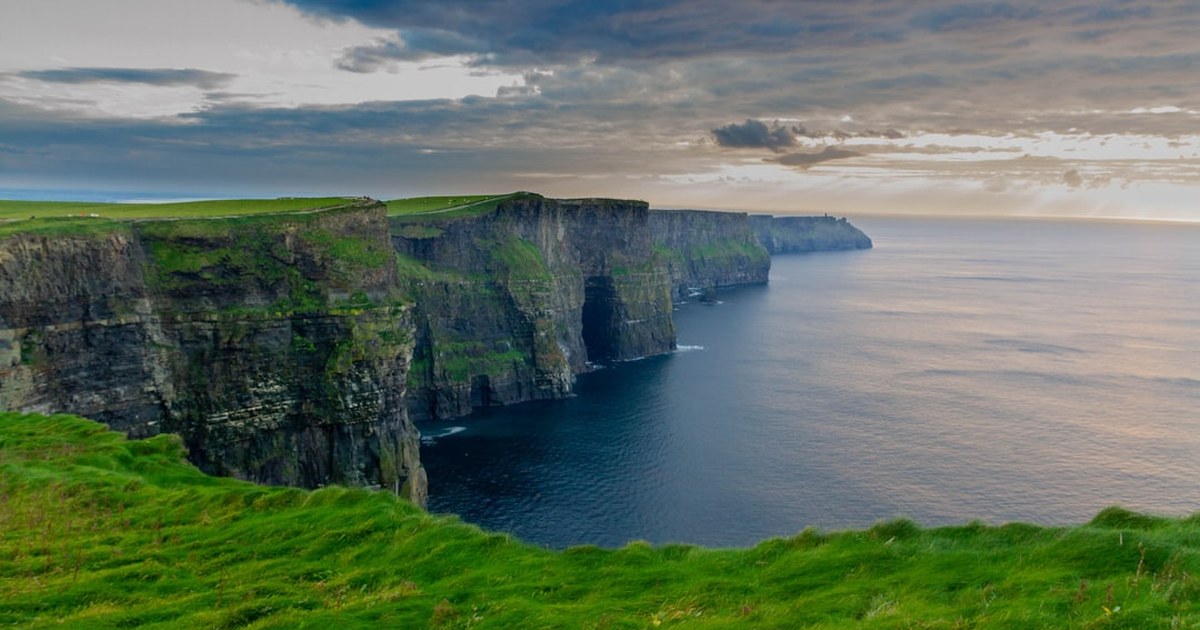
Most people standing at the edge of the Cliffs of Moher are thinking about the view. The Atlantic, the wind, maybe the drop. They are not thinking about the fact that the grey stone beneath their feet was once mud at the bottom of a tropical sea, deposited by a river delta the size of the Mississippi, in a country that was located somewhere near the equator at the time. They are not thinking about the 315-million-year-old sponge sealed inside the rock face, which waited until January 2024 to be formally introduced to science. They are definitely not thinking about the fact that the same stone under their feet was being quarried, a century ago, to pave the streets of Kensington and Mayfair.
The view west is tremendous. The view in — into the rock itself — is something else entirely.
A Tropical Delta, Compressed
The rocks that make up the Cliffs of Moher were formed between approximately 313 and 326 million years ago, during a period geologists call the Namurian stage of the Carboniferous. At that point, the landmass that would eventually become Ireland sat roughly 6,000 kilometres from its current position, just north of the equator, in a warm shallow sea battered by monsoon rains. The climate was comparable, according to the geological record, to the modern-day Bahamas or the equatorial tropics. Ireland was, briefly, a very different kind of place.
The rock layers visible in the cliff face were not laid down gradually in quiet water. They arrived fast. A massive river system, draining from a mountain range to the south that has since completely eroded away and no longer exists, carried enormous volumes of sediment — mud, silt, coarse sand — and dumped them at the river mouth in a delta that geologists compare in scale to the modern Mississippi. Coarser sediment from faster-moving water settled as sandstone. Quieter, deeper stretches settled as siltstone and shale. The cycle repeated, again and again, building up layers that would eventually be compressed into the cliff face we can see today.
You can read this directly in the rock. The lighter-coloured bands that form narrow ledges in the cliff face are sandstone — harder, more resistant to erosion. The darker layers that make up the bulk of the cliffs are softer siltstone and shale. Sandstone resists the Atlantic; shale gets eaten away beneath it. That differential erosion is precisely what creates the layered, stepped geometry of the cliff face. The staircase you see is not accidental. It is the direct imprint of water chemistry from 320 million years ago.
Individual strata vary in thickness from just a few centimetres to several metres, each one representing a distinct depositional event in the delta’s history. In places, up to 200 metres of these sedimentary rocks are exposed in a single cliff section. The formation has a name — actually several: the Central Clare Group and the Gull Island Formation, sitting above the older Clare Shale Formation at the base. To a geologist reading the cliff face, these units are chapters in a sequence running from deepest water at the bottom to near-shore conditions near the top.
Why Here, and Why This Height
The cliffs stretch for approximately 14 kilometres along the County Clare coastline. The maximum height — 214 metres — sits just north of O’Brien’s Tower. At Hag’s Head on the southern end, they stand at 120 metres. That variation reflects the local topography of the land surface as it meets the sea, shaped partly by the angle at which the Atlantic cuts into the rock.
What brought this rock above sea level in the first place was tectonic collision. Shortly after these sediments were deposited, the continent carrying them collided with what would become Europe, gently folding the rock layers. The cliffs display these folds — subtle warps in what were once horizontal beds. Elsewhere in the section, a feature called the Fisherstreet Slide records a more violent event: a sheet of seafloor sediment approximately 30 metres thick that moved as a submarine landslide before the rock had fully hardened, leaving behind intricate soft-sediment deformation structures still visible in the cliff face today. In the same geological neighbourhood, sand volcanoes — formed when pressurised water and sand punched upward through overlying layers — survive as frozen eruptions in the Carboniferous beds.
The tectonic plates carrying this rock have been moving at roughly 2 centimetres per year ever since. Over 300 million years, that adds up to approximately 6,000 kilometres of travel from a tropical sea to the western edge of Europe. The glaciations that began around 1.8 million years ago did the final sculpting: ice sheets more than 200 metres thick ground across the landscape, depositing boulders carried from distant regions — erratics, geologists call them — that still sit incongruously on the cliff top.
The Atlantic has been doing the rest. Wave action continuously undercuts the cliff base; the overhanging rock eventually collapses. The isolated sea stack called Branaunmore, standing 67 metres above the water offshore, is what remains when that process completes: a column of rock severed from the main cliff, left behind as the coastline retreats inland. In August 2026, a substantial section of Branaunmore broke away in the most significant rockfall observed there in twenty years — a live example of the same Atlantic forces described above, still doing their work.
What Lives in the Rock
The fossils in the Cliffs of Moher tell you, layer by layer, what the environment was doing as the sediment accumulated.
In the lower sections, the shale contains goniatite ammonoids — ancient cephalopods, relatives of the modern nautilus, that swam in the delta’s open waters. Goniatites are useful to geologists partly because different species evolved and went extinct on relatively tight timescales, making them precise dating instruments. These particular ones confirm the Namurian age of the rock. Crinoids — filter-feeding sea creatures that look like feathered stars on stalks — also appear in this part of the section.
Moving upward, the fossils shift. Marine creatures give way to trace fossils: the marks left by animals moving through wet sediment at the delta margin. The Liscannor flagstone underfoot at the visitor centre — quarried from the same geological unit visible in the cliff face — carries sinuous markings called Olivellites, the preserved feeding trails of marine gastropod-like creatures working through the ancient seafloor mud roughly 320 million years ago. Walk across the visitor centre floor and you are walking across the feeding ground of something that has no living descendants anyone has been able to name.
Higher still in the sequence, fossil plant roots appear — evidence that the delta had by that point built enough material above water to support terrestrial vegetation.
And in the Clare Shale Formation, geologists have found something unexpected: a neopteran pterygote insect — a creature with wings that could be folded over its body. Foldable wings were an evolutionary breakthrough that allowed insects to access confined spaces in plants and rocks that fixed-wing insects simply could not enter. The specimen from near Doolin is the earliest known example of this type of insect in the British Isles.
Eamon Doyle and the Giant
In January 2024, a paper appeared in the international journal Geobios describing a new species of fossil sponge discovered in the rocks near the Cliffs of Moher. The find belonged to Dr. Eamon Doyle, geologist for the Burren and Cliffs of Moher UNESCO Global Geopark — a man who has spent his professional life reading these particular rocks.
The sponge is approximately 315 million years old. It measures up to 50 centimetres in height. It is the largest known example of its type anywhere in the world. Its shape is vase-like, with a circular opening at the top surrounded by structures Dr. Doyle described as resembling eyelashes — calling to mind the Venus’s Flower Basket sponges that live today in the deep Pacific Ocean. The species name is Cyathophycus balori: the second half is a reference to Balor, the mythological Irish giant whose eye, when opened, brought destruction. The sponge’s prominent circular opening made the connection irresistible.
What makes the find scientifically significant is not just the size but the preservation. Sponges of this type are composed of a rectangular meshwork of tiny silica spicules held together by organic membrane. When the animal dies, that organic material decomposes rapidly and the whole structure falls apart. Finding one intact, at this scale, was — in the words of lead author Dr. Joseph Botting of the National Museum of Wales — “totally unexpected.” Dr. Botting and co-author Dr. Lucy Muir, also of National Museum Wales, collaborated with Dr. Doyle on the identification and description. The paper notes that the discovery “offers important insights into the evolution of sponges and how some species can survive in niche environments.”
When this sponge was alive, County Clare was near the equator in a warm, shallow sea, before the Atlantic Ocean existed. The rock containing it has since moved roughly 6,000 kilometres north. The sponge spent 315 million years in the cliff face before anyone noticed it. It had been there longer than vertebrate life has existed on land.
The Stone That Paved London
There is one more chapter to the Liscannor flagstones that seldom makes the itinerary.
The same geological unit that forms the flagstone paths at the visitor centre — the same rock face carrying 320-million-year-old feeding trails — was quarried at industrial scale throughout the 19th and early 20th centuries. At the peak of the trade, the quarries around Liscannor employed around 500 men across at least nine separate operations. The stone was loaded at Liscannor harbour and shipped out.
Liscannor flagstone paved streets in Kensington and Mayfair in London. It lined the docks at Liverpool — the same docks where Irish emigrants boarded ships during and after the Famine. It floored the cotton mills of Manchester during the Industrial Revolution. It appeared in Paris. It appeared in New York.
The Olivellites feeding trails visible underfoot at the Cliffs of Moher visitor centre, and the same trace fossils underfoot in a Victorian street in Mayfair, come from the same formation, quarried from the same ancient delta, deposited by the same vanished river system. The creature that made those marks lived once, 320 million years ago, and somehow ended up on two continents simultaneously.
The Archive at the Edge
Standing at the cliff edge, it looks like solid, permanent geography — the most stable kind of scenery imaginable. What the view does not convey is that none of this is fixed. The Atlantic is still undercutting the base. The cliff edge retreats inland by measurable amounts. Branaunmore was once part of the main cliff face and is now an island of rock. The insect with foldable wings waited in the Clare Shale for the better part of 320 million years. The sponge named after a mythological giant spent longer than that in the cliff face before anyone found it.
The tectonic plate is still moving. Two centimetres a year. It has not stopped.
What you are standing on, when you stand at the Cliffs of Moher, is not scenery. It is an archive — a 200-metre-thick, compressed record of a tropical river delta, a shallow equatorial sea, a mountain range that no longer exists, and the creatures that lived and died before anything with a backbone had found its footing on land. The cliffs are not old in the way that old buildings are old. They are old in the way that deep time is old: unimaginably, productively, usefully old. Every ledge has something to say. Most of it has barely been read.
County Clare has been carrying these rocks for a very long time. We are glad they ended up here.
☘️ Join 64,000+ Ireland Lovers
Every Friday, get Ireland’s hidden gems, local secrets, and travel inspiration — the kind you won’t find in any guidebook.
Already subscribed? Download your free Ireland guide (PDF)
Free forever · One email per week · Unsubscribe anytime
Tours & experiences you might love


Powered by Viator. Some links are affiliate links — we may earn a small commission at no extra cost to you.
Secure Your Dream Irish Experience Before It’s Gone!
Planning a trip to Ireland? Don’t let sold-out tours or packed attractions spoil your journey. Iconic experiences like visiting the Cliffs of Moher, exploring the Rock of Cashel, or enjoying a guided walk through Ireland’s ancient past often sell out quickly—especially during peak travel seasons.

Booking in advance guarantees your place and ensures you can fully immerse yourself in the rich culture and breathtaking scenery without stress or disappointment. You’ll also free up time to explore Ireland’s hidden gems and savour those authentic moments that make your trip truly special.
Make the most of your journey—start planning today and secure those must-do experiences before they’re gone!